If “the 20” Could Talk: Gentrification along Portland’s Burnside Street and the history that shaped it
By: Alie Kilts
In Portland, it doesn’t take long to blend in with the locals when it comes to orienting yourself. Get to know a couple main arteries, learn how to pronounce some not-so-obvious street names, and, most importantly, be able to say which direction you live in. Portland is divided by a river, called (another name that trips the non-local) “The Willamette”. That is pronounced Will-Am-It. Not Willa-Met. Not Willa-Metty. Willamette, with a hard A. The Willamette divides East and West Portland. On the West side is downtown, the “West Hills” and one of the largest urban forests in the United States, Forest Park (“Experience Forest Park”). On the east side are the SE, NE and North Portland neighborhoods. Dividing North and South, downtown, Chinatown and Powell’s Books from Sizzle Pie is Burnside Street. Originally named “B” Street, following the Alphabet district (“Burnside Street History”), Burnside has a little bit of everything. Five star restaurants, homeless shelters, chic vintage, strip clubs, a world-renowned book store and a bridge with one of the best views of the city. Burnside’s transformation over the years has left some parts untouched, while others, unrecognizable.
Growing up just a few blocks from Burnside, I spent a lot of time riding it’s bus, “the 20”. In middle school, Monday through Friday, every morning and afternoon, I would exchange my 90 cent ticket for a bus transfer and embark on my journey. Each trip, I would cram the wispy transfer into my book bag, only to cause an eruption of crumpled up paper every few months. Every morning I was running late, every afternoon I was dragging to get back on knowing what homework was waiting for me. Bus 20 was part of my routine. Over the course of my 18 years (from birth to the age of 18), very few things changed on Burnside. A couple local businesses were bought out by corporations with a fancy new logo. A seldom apartment complex was remodeled. And Music Millennium, the local independent record store, went through a rollercoaster of trying to keep its doors open. Not a lot changed. When I left in 2007, Burnside was known to be a little on the seedy side with corner stores peppered up and down. Now, ten years later, Burnside is one of the most transformed and controversial streets in Portland.
In this paper, I will focus on the first 30 blocks of East Burnside. This is by far the most transformed part of of the street–the entire length runs over 15 and a half miles (“W/E Burnside”). I will start with the history of the street planning, talk about the evolution of transit and recount my experiences growing up around this main artery. Along with my historical research and lived experiences, I have created overlays using Google Maps to highlight some of the major changes that have occurred in the last 10 years. These images give a glimpse into the past, represent the present and will be a catalyst to talk about the future of Burnside.
The History of Burnside
Oregon was founded in 1859 and Burnside came shortly after. Originally named ‘B Street’, Burnside was part of the Alphabet District in NW Portland, laid out by Captain Couch (pronounced Cooch). C street later was named after the Captain himself; another street that will quickly prove if you’re a local or a transplant. Soonafter its inception, Burnside became the hangout for visiting sailors. “The street’s reputation for saloons and sailors made it almost impossible for respectable businesses to be located on Burnside.” (“Burnside Street History”). In 1892, the streets name was changed to Burnside, named after a Portland Merchant, David W. Burnside. In 1903-1915, the predecessor to the bus, the streetcar was implemented, linking the West and East neighborhoods divided by the Willamette River. Despite other neighborhoods continuing their lines, Burnside’s streetcar closed; thought to be due to the “undesirable nature of the street” (“Burnside Street History”). In 1912, The Bennett Plan was proposed by Edward H. Bennett; more famously known for his co-authorship of the 1909 Plan of Chicago (Burnham, Bennet, 1909). His plan proposed to widen the street and turn it into the “Grand Cross of intersecting axials by means of the intersections of Burnside Street, the main axial thoroughfare with Union Avenue [today, Martin Luther King Avenue] on the East side and the Park Blocks on the West side…Such a plan is exemplified very conclusively in the capitals of Europe and is being slowly developed in the cities of this country.” (Bennet, 1912). In 1919, a new bridge designed for cars was proposed to alleviate the traffic caused by the growing number of automobiles on the road. Traffic increased by almost 400% between 1917 and 1925 (“Burnside Street History”). The Burnside Bridge opened in 1926, equipped with pedestrian walkways and dedicated lanes for streetcars to cross. As time went on, traffic continued to get worse and the need for more roads was apparent. In 1931, Burnside underwent a street widening, literally chopping off the facade of buildings and turning many first floors into the new sidewalks.
As Burnside became more and more car-centric, removing the streetcar lane on the bridge came into discussion. The street that used to be lined with saloons was now getting replaced by car dealerships (“Burnside Street History”). By the 1940s, widening Burnside again was out of the question, but the idea of separating different forms of traffic was starting to catch on from bigger metropolises at this time starting to adopt freeways. Robert Moses proposed a freeway loop similar to the loop that is there today, separating local traffic from transit and pedestrians (“Moses Plan”). By the 1950s, buses started to replace streetcars due to their compatibility with automobiles. During WWll, public transportation saw an all-time high of 169 million rides a year. But after the war ended, cars were back to being the predominant form of transportation, bringing ridership to a mere 16 million rides a year (“Burnside Street History”). Before 1969, there were up to seven different companies operating the buses, but after a resolution passed by the Portland City Council, Tri-County Metropolitan Transportation District of Oregon, otherwise known as ‘Tri-Met’ was formed. In 1973, bus routes were assigned number (instead of being designated by street names) and that’s where “the 20” was born. Today, the heyday of car dealerships is fading and giving way to apartments and condos. As Portland’s population continues to rise, new needs are being met…but for who?
Burnside 2000-2017
Much of today’s new development has started at the waterfront along the opening of the Burnside Bridge. The next ten images are overlays I created using Google Street View, comparing today’s view to sometime in the past 10 years. I will start with the mouth of the bridge and continue up Burnside all the way to 30th Street.
Burnside Bridgehead
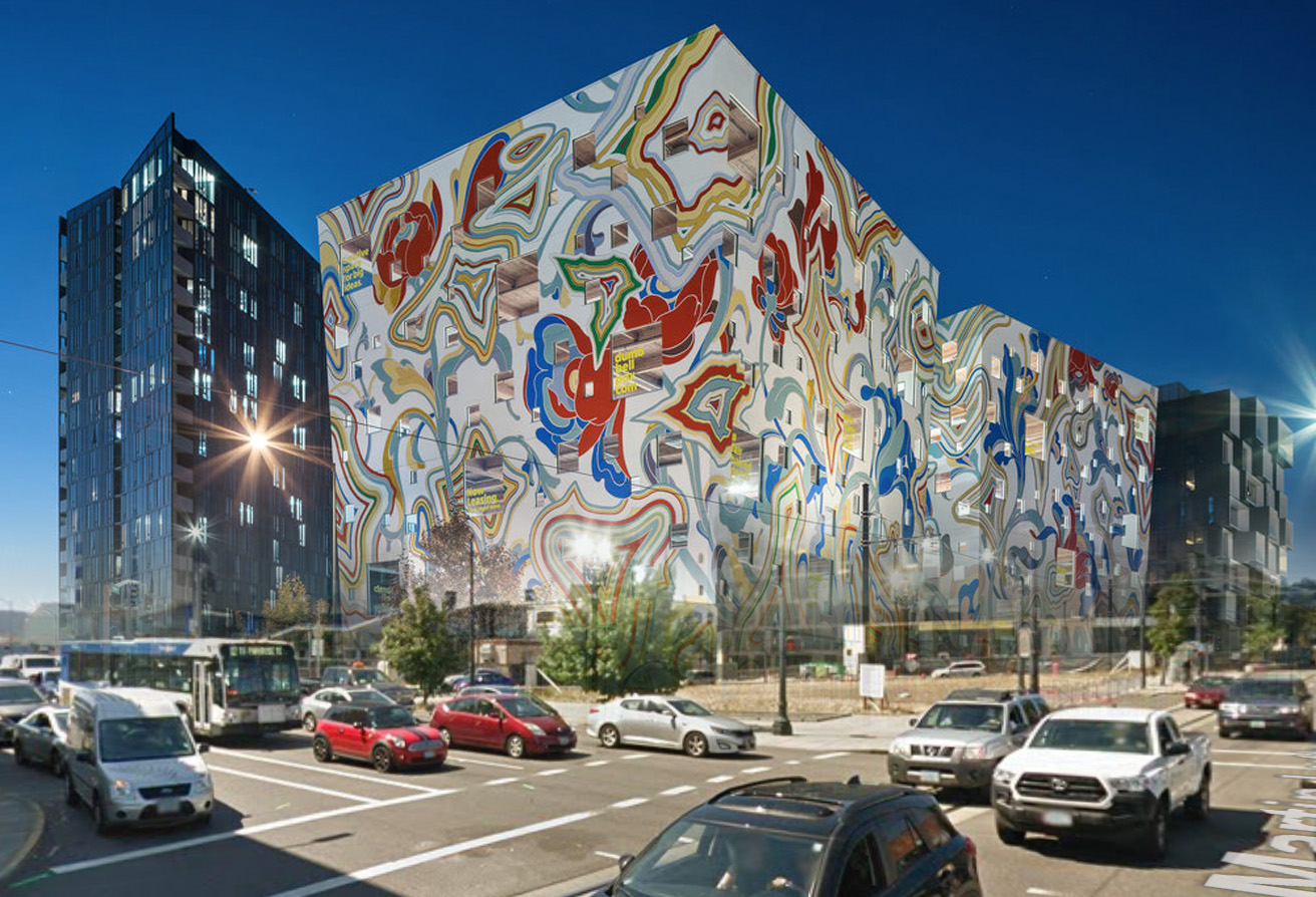
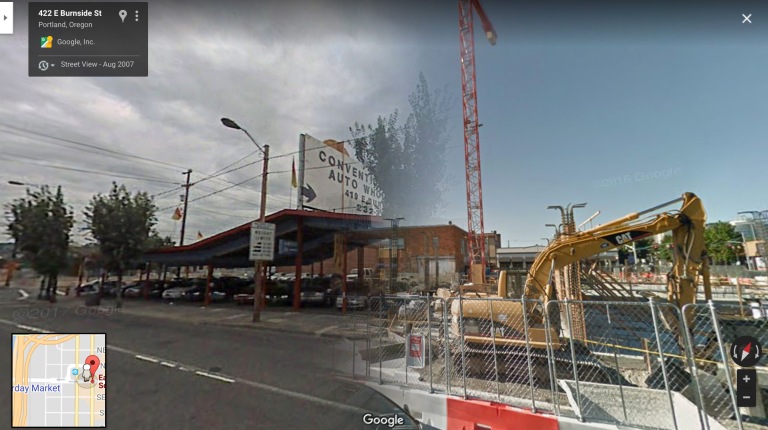
Being butted up against the waterfront, the mouth of the Burnside Bridge has become sought after real estate. The first large development project was the 21-story Yard apartment complex, but it did not go up without a fight. On top of it being one of the tallest buildings on the East side of the river, there were many concerns about it becoming an eyesore due to some esthetic requirements that were not met (“Portland Misses ‘Unfortunate’ Design…” 2016). Situated across the street from the Yard, in what seems like an impossible piece of land to develop is the new Fair-Haired Dumbbell building. A mixed-use (non-housing) space with a mission of not being “another grey building” in Portland (Dumbbell 2017). Directly across the street is the construction (former car dealership) site for another mixed-use residential building.


Figure 4a (left): An overlay of the tallest new Burnside development in 2016. The Yard apartment building standing at 21 stories of residential studios to two-bedroom apartments at the mouth of the Burnside Bridge. The original photo with no development is from 2009. Source: Google Maps. Figure 4b (middle): Another overlay of the Yard looking West. This photo shows the original landscape from 2007, the beginning of the construction in 2015 and the completion in 2016. Source: Google Maps. Figure 4c (right): An overlay of a rendering of Portland’s controversial Dumbbell building, compared to a 2016 Google Street View photo of the plot of land. The Fair-Haired Dumbbell was completed at the end of 2017 and sits at the East end of the Burnside Bridge at the intersection of E. Burnside and Martin Luther King Jr Blvd. Source: Google Maps.
Burnside/Sandy Blvd. Intersection
Formerly a parking lot, and one of Portland’s oldest feminist-owned restaurants, ‘Old Wives’ Tales’, now sits two apartment complexes, the ‘Linden’ and ‘The Alexander’(“Old Wives’ Tales Closes…” 2014). This intersection has seen a lot of investment in night life; possibly due to the developers having their eye on a certain age and income bracket (“Peeling Back Layers” 2018).


Figure 5 (left): An overlay of the intersection of Burnside and Sandy Blvd. Once a parking lot (2009), now apartments (2014). Source: Google Maps. Figure 5b (middle): An overlay of 13th and Burnside where the Portland staple, Old Wives’ Tales had a 34 year run. Owner, Holly Hart originally opened the restaurant because there was a lack of non-bar settings for the LGBT community to meet and hang out in. “We’ve outlived our usefulness, and that’s awesome.” Source: “Old Wives’ Tales Closes…” 2014, Google Maps. Figure 5c (right): An overlay of a former business (2007), now turned into the Dorian apartment complex (2016) on Burnside between 14th and 15th. Source: Google Maps.
Continuing Up Burnside
Along with the new housing developments, the city implemented some safety upgrades documented in the above image, “E Burnside Improvements”. With the influx of people moving into the neighborhood, these safety improvements couldn’t come at a better time. PBOT has dubbed East Burnside to be a “High Crash Corridor”. Along with newly paved roads and reduced speed limits, other improvements consist of curb extensions, pedestrian islands and signal modifications (“East Burnside Safety Improvements”). Previously addressed in the closure of the Portland staple, Old Wives’ Tales, businesses up and down Burnside face similar fates. A long-time Portland classic with a 20 year reign, Chopsticks ll, a karaoke bar serving up mediocre Chinese food was forced to shut its doors by the landlord of the property. This didn’t come as a surprise to most Portlanders, seeing as a massive apartment complex, Burnside 26 went up in the summer of 2014 and the sign of Chopsticks was shining into presumably someone’s bedroom. The property management company made a statement, “This is a neighborhood that’s developing. In addition to apartment and condo construction, a number of new businesses have transformed Chopsticks’ section of East Burnside…”, basically implying that Chopsticks no longer caters to the clientele the neighborhood is now being built for (“Chopsticks ll Will Close” 2014). The poetic justice of it all: nothing has moved into the old Chopsticks space, yet the sign is still stands.
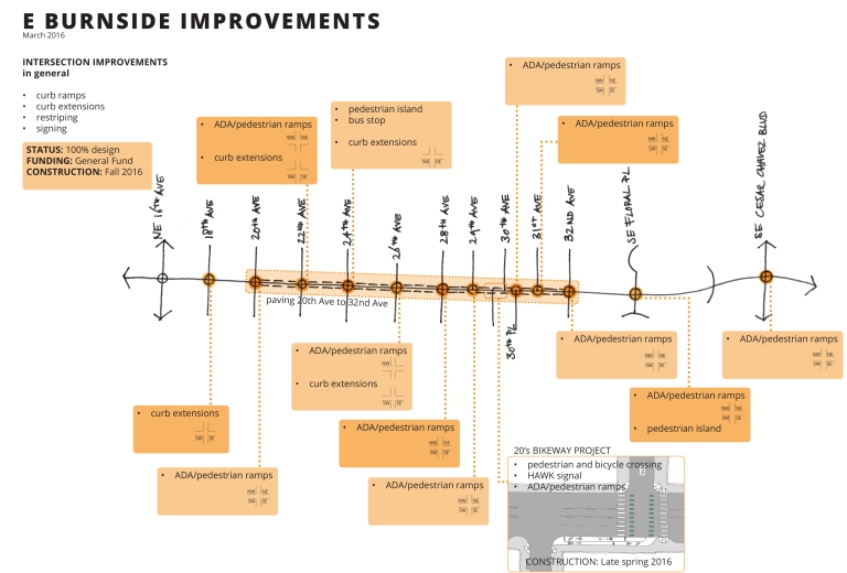
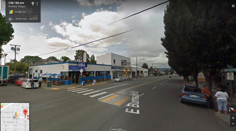
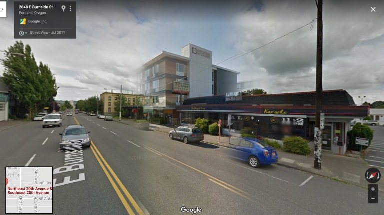
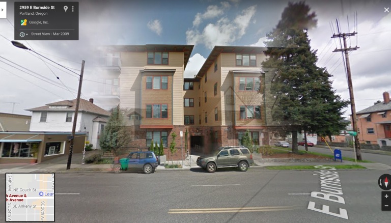
Figure 6a (top): The East Burnside Safety Improvements Plan implements curb extensions, pedestrian islands, new pavement and signal modifications. Source: “East Burnside Safety Improvements”. Figure 6b: An overlay of the intersection of Burnside and 18th taken in 2007, compared to a 2015 view highlighting the addition of a crosswalk. This crosswalk is part of the East Burnside Safety Improvements Plan starting at this intersection and going up to 39th. Source: “East Burnside Safety Improvements”, Google Maps. Figure 6c: An overlay of the former location of Chopsticks II, taken in 2011, compared to this 2016 view of Burnside 26, a new apartment building butted up against the Chopsticks sign. As of today (December 2017), if you go to Burnside between 26th and 27th, the Chopsticks building still remains with no sign of construction or new business. Source: Google Maps. Figure 6d: An overlay of a vacant lot from 2007, and the Sunrose Condominium in 2011 on the corner of 28th and Burnside. This was some of the first new development along Burnside and the only condos among these 11 sites I’m focusing on. Source: Google Maps. Figure 6e: An overlay of houses that used to be located at 30th and Burnside, and the apartment complex, B Street Apartments (an homage to the former name of Burnside) in 2014. Source: Google Maps.
Burnside’s Future
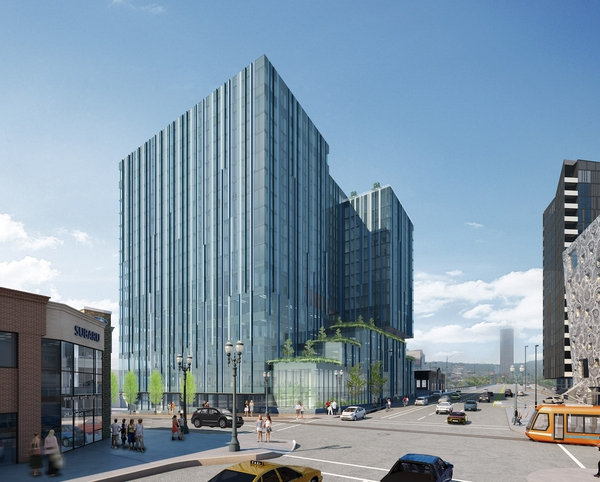
Like many growing cities, Portland is in a housing crisis. So the inclination to build more housing is warranted, but affordability is in question. While Portland’s rents raise at a reported 14% annually (“14 Percent Annualized…” 2015), and half of the renters are considered rent burdened (more than 30% of income toward rent), the affordability crisis is real (“Can Portland Avoid…” 2016). Meanwhile, Burnside continues to build it’s skyline with the soon-to-be 5 MLK building. A 17-story, multi-use complex at the bridgehead of Burnside across the street from the previously mentioned 21-story Yard apartments. So the question is, what can we expect next? From dirty saloons to glammed out car dealerships to luxury apartments, Burnside has seen it all. Will history repeat itself? Or is there a new trend on the horizon? I’ll check back in with you in a decade.
Bibliography:
“1930 W. Burnside before Widening | Portland Timeline Images | The City of Portland, Oregon.” n.d. Accessed December 12, 2017. https://www.portlandoregon.gov/archives/article/24737.
“1931 W. Burnside after Widening | Portland Timeline Images | The City of Portland, Oregon.” n.d. Accessed December 12, 2017. https://www.portlandoregon.gov/archives/article/24739.
“A History of Public Transit in Portland.” n.d. Accessed December 12, 2017. https://trimet.org/history/transitinportland.htm.
Bennet. The Greater Portland Plan of Edward H. Bennett /. 1912. Portland : http://hdl.handle.net/2027/hvd.32044026855619.
Burnham, D.H., Bennet, E.H. Plan of Chicago 1909. Chicago: http://uvadoc.uva.es/bitstream/10324/10241/1/CIUDADES-2002-2003-7-PLANOFCHICAGO.pdf
“Burnside Street History | Burnside + Couch Project | The City of Portland, Oregon.” n.d. Accessed December 12, 2017. https://www.portlandoregon.gov/TRANSPORTATION/article/295412.
“East Burnside Safety Improvements | The City of Portland, Oregon.” n.d. Accessed December 12, 2017. https://www.portlandoregon.gov/TRANSPORTATION/70554.
“Experience Forest Park | The Forest Park Conservancy.” n.d. Accessed December 12, 2017. http://www.forestparkconservancy.org/forest-park/.
“Moses Plan | Portland’s Transportation History | The City of Portland, Oregon.” n.d. Accessed December 12, 2017. https://www.portlandoregon.gov/transportation/article/66086.
Nextportland. 2016. “Under Construction in the Central Eastside: 419 E Burnside (Images).” Next Portland (blog). March 2, 2016. http://www.nextportland.com/2016/03/02/419-e-burnside/.
Oregonian/OregonLive, Luke Hammill | “14 Percent Annualized Rent Growth in Portland ‘Landlord’s Market,’ Report Finds.” OregonLive.Com. Accessed December 12, 2017. http://www.oregonlive.com/front-porch/index.ssf/2015/10/14_percent_annualized_rent_gro.html.
Oregonian/OregonLive, Luke Hammill | “Portland Misses ‘Unfortunate’ Design Change to 21-Story Tower at Burnside Bridgehead.” OregonLive.Com. Accessed December 12, 2017. http://www.oregonlive.com/business/index.ssf/2016/01/portland_misses_design_changes.html.
Oregonian/OregonLive, Melissa Binder | “Old Wives’ Tales Closes, Building Sold to Apartment Developer; Owner Says Progressive Restaurant ‘Outlived Usefulness’ (Q&A).” OregonLive.Com. Accessed December 12, 2017. http://www.oregonlive.com/portland/index.ssf/2014/05/old_wives_tales_closes_buildin.html.
Semuels, Alana. 2016. “Can Portland Avoid Repeating San Francisco’s Mistakes?” The Atlantic, May 17, 2016. https://www.theatlantic.com/business/archive/2016/05/the-real-roots-of-portlands-housing-crisis/482988/.
TriMet. “Making History.” Making History. Accessed December 12, 2017. http://trimet.org/makinghistory/.
“W/E Burnside Street | The City of Portland, Oregon.” n.d. Accessed December 12, 2017. https://www.portlandoregon.gov/transportation/61206.
“Welcome.” n.d. Dumbbell. Accessed December 12, 2017. https://www.dumbbellpdx.com/.
Willamette Week, Matthew Korfhage | “A 17-Story Highrise Will Soar Over the Burnside Bridgehead.” wweek.com. Accessed December 12, 2017. http://www.wweek.com/culture/2017/06/20/a-17-story-highrise-will-soar-over-the-burnside-bridgehead/.
Willamette Week, MAtthew Korfhage | “Chopsticks II Will Close.” wweek.com. Accessed December 12, 2017. http://www.wweek.com/portland/blog-32449-chopsticks-ii-will-close.html.
Williams, April Baer | Jonathan. n.d. “Peeling Back Layers On Portland’s Infill Development.” Accessed December 12, 2017. http://www.opb.org/radio/programs/state-of-wonder/article/portland-development-infill-housing/.
